The story of Coastal Douglas-fir forests: All about Mayne Island
Though smaller and more developed than some of its counterparts in the archipelago of islands in the Salish Sea, in this article, Rob Underhill explains why SḴŦAḴ (Mayne Island) is a place worth protecting.
The Coastal Douglas-fir biogeoclimatic zone (“CDF zone”) is the most biologically diverse in British Columbia. Though the CDF zone is distinctive as a region, part of what makes it so special is the mosaic of smaller and unique habitat types that make it up. The Gulf Islands are among the best examples of the way different pockets of the CDF can be so representative of the zone’s characteristic attributes while also being deeply unique.
This article about Mayne Island is the fourth installment in a special collection of island-specific spotlight articles within the Story of the CDF, featuring the insights and expertise of Rob Underhill, biologist with the Mayne Island Conservancy. This article highlights the innovative land protection work done by the Mayne Island Conservancy and unveils the mysteries of an island sometimes overshadowed by its larger neighbours. Other articles in the “Island Collection” profile are Galiano, Gabriola, and Hornby Islands.
Topography: Shaped by the land
SḴŦAḴ or Mayne Island is one of the Southern Gulf Islands. These islands are the relatives of W̱SÁNEĆ People, who, despite being forcefully displaced from much of their rightful ancestral Territories since the arrival of European settlers, remain the dedicated stewards of SḴŦAḴ and the surrounding areas.
Mayne is nestled between Galiano to the north and Saturna and the Penders to the South. It has a land area of 23 km², which is composed of a series of very steep south-facing slopes contrasted against long, lower degree, north-facing slopes. One of the things that makes Mayne Island different from its neighbours is how this topography has influenced the distribution of wetter ecosystem types like wet forests and wetlands.

These characteristic wet ecosystem types are principally concentrated in two big valleys. The first stretches nearly the entire expanse of the island between Miners Bay on its western end to Bennett Bay at its northeastern edge. This valley tends to be a blindspot even for people who are very familiar with Mayne Island because there are few vantage points from public roads and limited entries that provide public access. The second valley is near Horton Bay on the southeast end of the island, which is predominantly under the ownership of a single landholder.
Though topography and other biogeoclimatic influences drove the natural distribution of habitat features once distinctive to Mayne, patterns of settler land ownership (and agricultural development in particular) have had a significant influence on modern-day Mayne.
Industry: Shaped by people
Despite the size of these valleys and the wet ecosystems they historically fostered, there are currently fewer intact wet ecosystem types on Mayne compared to Galiano, North Pender, or Saturna Islands, where the size and distribution of such ecosystem types are naturally smaller and more scattered. Because smaller pockets of wet habitats are not as desirable for agricultural development, those that exist on these neighbouring islands remain intact today. Conversely, a notable area of valley-bottom wetlands on Mayne has been converted over the past 150 years.
In the early 2000’s, when the Gulf Islands National Park Reserve was just being formed, the province of British Columbia produced Terrestrial Ecosystem Mapping for the Southern Gulf Islands. The resulting dataset has myriad uses, one of which is recording and monitoring land use change. According to an analysis completed by the Mayne Island Conservancy (“the Conservancy”), at least 74% of the island’s four wettest forest ecosystem types have been lost. Likewise, more than 30% of the island’s total land area has been converted to other land uses. Based on continuing development pressure–not only on Mayne Island, but across the region–a threshold is being reached where it is likely that some species and ecosystem types will begin to disappear permanently.

Its sheltered location right in the center between Victoria and Vancouver historically made Miners Bay an important stopover for early settlers, making Mayne an earlier target of development and subdivision. This resulted in early fragmentation of the landscape into 40 to 50-acre parcels. So when National Park acquisitions first started, about five decades ago, the Island had fewer large attractive properties in which to invest resources, translating into fewer protected areas.
Another past activity that has reverberating effects on the current ecology of Mayne Island is logging. “Good” (i.e., ecologically-informed) logging practices can minimize impacts on the forest ecosystem and encourage forest regrowth, protect biodiversity, and ensure that there will be a forest to enjoy, protect, and/or harvest from in the future. However, this sort of logging was not necessarily practiced when commercial-scale logging was more widespread on Mayne. Much of the harvesting took place as part of the subdivision process, so it may be more accurately described as land development as opposed to a professional timber harvest.
Many of the lots formed as part of this subdivision are three to four acres in size, and were flattened, compacted, and in many cases colonized by invasive plants. Despite this level of disturbance, there are still opportunities to engage with community members to steward these properties to reintroduce ecological functionality and reestablish habitat for native species. These areas of disturbance drive an urgency to protect the remaining ecologically intact areas of the island.

Plant diversity: Shaped by… deer?
The development pressure on Mayne is exacerbated by a ballooning deer population. Like other Southern Gulf Islands, Mayne is plagued by a hyperabundant population of native black-tailed deer that has resulted from the extirpation of natural predators. The introduction of fallow deer to Mayne in the early 1990s has exacerbated the problem. Yet, it is difficult to quantify the true scale of impact.
Though a number of studies have been completed across the CDF zone that have improved understanding of local deer abundance, deer densities can be challenging to accurately calculate. Pellet counts are a common method, but require assumptions to be made about defecation rate and pellet persistence. Simply counting individual deer observations is another approach, but this relies on deer being seen by observers. Further, double-counting is possible as it can be tricky to distinguish one individual deer from another.
Nonetheless, studies by researchers like Dr. Peter Arcese (2008, 2011, 2014) and Dr. Tara Martin (2011, 2022) from the University of British Columbia, complemented by community-led studies by local organizations like the Mayne Island Deer Management Society, have helped to form a better understanding of the deer situation on a number of Gulf Islands. Based on the results of such studies on Mayne, the best estimates available suggest that the deer density is likely in the range of 0.5~2 deer per hectare (ha). While this means that browse pressure can be very intense, observations in different parts of the island indicate that there is variability in the distribution of that pressure. There are some areas where there is almost no understory and others where a great diversity of native plants continues to grow.

As an interesting comparison, in the spring of 2025, a visit to Tumbo Island in the Gulf Islands National Park Reserve indicated that Tumbo experiences a similar impact as Mayne to herbaceous plant communities, despite a potentially lower deer density (1.31/ha +/- 0.24) based on a pellet count compared to Mayne Island (Beckett, 2022). This highlights that for many native plants and ecosystems, the impacts of deer overpopulation are severe even at relatively low deer density.
Aforementioned studies by Dr. Arcese and others suggest deer populations should be maintained at 0.08 deer/ha (i.e., 8 deer/km²) or lower to maintain culturally and ecologically significant plant communities. In the absence of predators, the deer population on Mayne is largely uncontrolled, with the exception of a few very active local provincially-licensed and Indigenous subsistence hunters who collect from their private properties or the WJOŁEŁP (Tsartlip) reserve at Helen Point. That is not to say that many additional efforts have not been made to find a solution to this problem. About five years ago, the Capital Regional District (CRD) coordinated an Indigenous hunt on Mayne, resulting in the removal of about 50 deer from the population.
More recently, the Conservancy purchased the supplies for and facilitated a number of deer butchering workshops for members of the Tsartlip Nation and the broader Mayne Island community to continue to encourage hunting. For a long time, the Mayne Island Fallow Deer Committee, an ad hoc community group, formed around the issue. Yet, all of these efforts have been temporary, with limited resources. The Mayne Island Conservancy lacks the mandate and expertise to manage wildlife in this way, beyond educating the public on the ecological impacts of an ecosystem out of balance. Luckily, in 2025, another local organization was formed called the Mayne Island Deer Management Society. This new society now leads community population counts and may eventually be able to establish the continuity needed to make more meaningful change over time, especially when guided by continuing and emerging research by Dr. Tara Martin’s Conservation Decisions Lab at the University of British Columbia.
Conservation efforts on Mayne Island
One way to think of Mayne is in comparison to Galiano. The two islands have similar populations, but Mayne has one-third of the land area. In combination, high rates of land conversion, significant land subsidization, and a high population density on Mayne have resulted in fewer opportunities for conserving large, undeveloped areas. However, the Mayne Island Conservancy has harnessed these historic patterns of land ownership and is using them to roll out innovative approaches for protecting the ecosystems that remain.
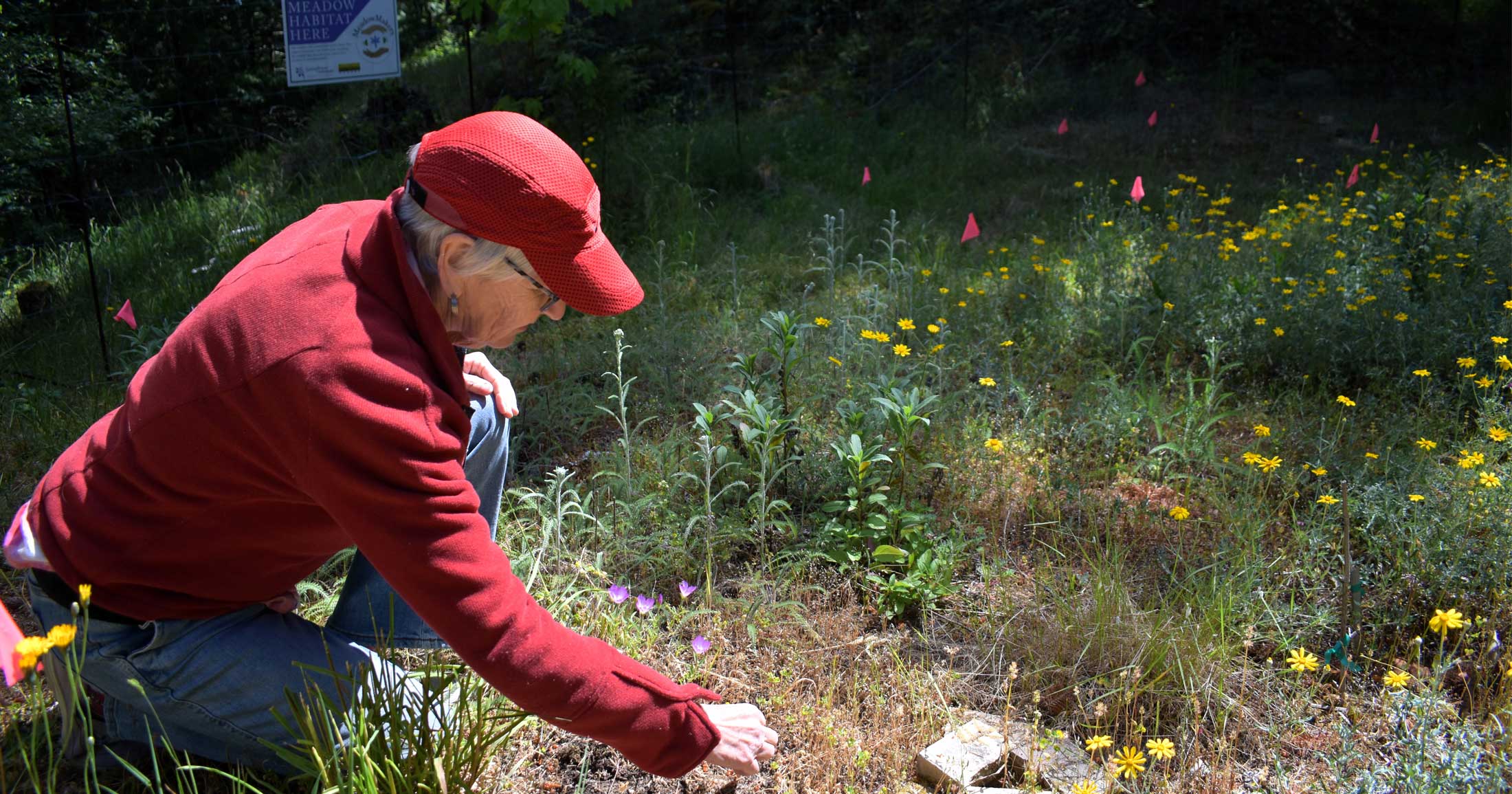
Because opportunities to pursue land purchase and conservation covenants are limited, the Conservancy works closely with private landholders (who own about 80% of Mayne’s land area) to foster a culture of land stewardship. Under this approach, the number of small private properties on the Island means that there is a giant pool of potential land stewards who can help invest resources in ecological restoration work, such as removing invasive plants, building deer exclosures, and caring for sensitive species or ecosystems that may exist on their properties. In recent years, there seems to be an increasing number of landholders who are interested in engaging with this sort of ecosystem stewardship and connecting with the land where they live.

Working with private landowners means getting people excited about land and ecosystems. As such, the Conservancy has established a robust education program and hosts many public events to inspire people about the magic of Mayne Island nature. They run a youth education program to provide inspirational nature-based experiences to the next generation in collaboration with the Mayne School, Mayne Island Early Childhood Society, and local families.


Adult community members are engaged through programs such as the Southern Gulf Islands Bull Kelp Monitoring Collaboration, a kayak-based, surface extent monitoring program which was founded by Mayne Island Conservancy in 2010 and expanded to include Galiano, Saturna, and the Penders (with participation from Valdes Island as capacity allows). Data is collated into annual reports that are made publicly available and used by academics, First Nations, provincial and federal governments.
As if their Land Stewardship Program, education initiatives, and monitoring work were not enough, two additional cornerstones of the Mayne Island Conservancy’s work are the complementary operation of 1) an in-house native plant nursery where about 40 different plants are propagated, and 2) a Land Consultation Program, which provides advice to those seeking to better steward their properties.
Plants from the nursery are used to supply the Conservancy’s own restoration projects, and any surplus is sold to private landholders. These sales often lead to land consultation opportunities, which involve an initial desk-based analysis of available data from a given property area, followed by a site survey to identify plants and animals, areas of high conservation value, and best practices for stewardship action, such as leaving rotting wood in place, planting more native species, and removing invasives.
Since 2008, over 200 in-person landholder consultations have been completed. Sometimes, at the request of the landholder, these consultations then translate into more formalized land protection ranging from voluntary stewardship agreements to legally binding long-term covenants.

At present, the Conservancy holds two conservation covenants: one at St. John Point (which is now a Regional Park) and the other near Horton Bay. They also own a half-acre of property, and helped the Nature Conservancy of Canada to protect 87 acres at Edith Point.
In total, the Conservancy engages the community in habitat restoration work within 400 acres of public parks in partnership with a variety of landholders (e.g., Parks Canada, CRD, etc.). This includes invasive species removal, designing restoration plans, planting native species, and myriad other activities. In an effort to expand this work, the Conservancy’s board recently adopted a strategic vision to protect 30% of the Island by 2033. To illustrate the ambition of that target: in 2015, less than 5% of the island was under some form of protection, and now in 2026 that number has more than doubled to almost 11%.
Mayne Island is smaller and more broadly developed than some of the other Gulf Islands, but despite the size of the human footprint on the Island, it is a unique place worthy of conservation investment. From the windswept bluffs of Georgina Point to the forested trails of Mount Parke and the protected waters of Bennett Bay, the Island still supports Garry oak meadows, pocket wetlands, eelgrass beds, and critical habitat for migratory birds and marine life.

The strategic conservation efforts of the Mayne Island Conservancy and the wider Mayne Island community will safeguard these interconnected coastal and upland ecosystems while preserving the rural character and ecological resilience that define the Island within the Gulf Islands archipelago.
About Rob Underhill
Rob Underhill is a Registered Professional Biologist and has been working in habitat restoration and native plant propagation in Coastal Douglas-fir ecosystems for the past 18 years.
References
Arcese P, Schuster R, Campbell L, Barber A, Martin TG. 2014. Deer density and plant palatability predict shrub cover, richness, diversity and aboriginal food value in a North American archipelago. Bradley B, editor. Diversity and Distributions. 20(12):1368–1378. doi:https://doi.org/10.1111/ddi.12241.
Beckett K, Elle E, Kremen C, Sherwood A, McComb S, Martin TG. 2022. Hyperabundant black-tailed deer impact endangered Garry oak ecosystem floral and bumblebee communities. Global Ecology and Conservation. 38:e02237. doi:https://doi.org/10.1016/j.gecco.2022.e02237.
Gonzales EK, Arcese P. 2008. Herbivory more limiting than competition on early and established native plants in an invaded meadow. Ecology. 89(12):3282–3289. doi:https://doi.org/10.1890/08-0435.1.
Martin TG, Arcese P, Scheerder N. 2011. Browsing down our natural heritage: Deer impacts on vegetation structure and songbird populations across an island archipelago. Biological Conservation. 144(1):459–469. doi:https://doi.org/10.1016/j.biocon.2010.09.033.